Climate Change Study Wins NASA Grant
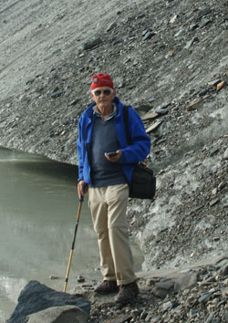
Back In 1969, before he came to Keene State, Professor Emeritus of Geography Klaus Bayr decided to climb the Grossglockner, the highest mountain in his native Austria. He’s been back many times since, and during those visits, he became familiar with the nearby Pasterze Glacier, the largest in the eastern Alps. And during those visits, he became aware that the Pasterze was changing. “The glacier is shrinking—terribly—it’s lost a lot of mass,” Dr. Bayr observed.
The Margaritze Reservoir collects the meltwater of the glacier, and a hydroelectric power station uses that water to produce electricity. So far, the Pasterze is producing plenty of meltwater, “but if the glacier melts away, it will obviously affect power production,” Dr. Bayr observed. He has been working with the National Aeronautics and Space Administration (NASA) http://www.nasa.gov/ since the 1980s to study the glacier’s rate of recession. NASA supplies satellite data and images, and Dr. Bayr has been ground truthing that data—walking the glacier’s perimeter, with GPS in hand, to determine its exact edge. Glaciers push a lot of till in front of them: rocks, dirt, and debris. With sometimes several feet of till on top of the ice, it’s difficult to tell from satellite photos just where the glacier ends. Dr. Bayr’s ground truthing supplies that essential data.
The study’s conclusion is that the Pasterze Glacier has receded 1255 meters since 1880 and approximately 786 meters since 1965. In addition to the loss of length, the height of the glacier tongue decreased by 88 meters which resulted in 456 million m³ of water discharge.
Recently, Dr. Bayr received a NASA grant of $26,471 to hire a student, Christopher Dunn, a senior geography major, to help him create a series of 3D models of the glacier from different years to show how the Pasterze’s height and volume has changed since the 1980s. The project is titled “Production of 3D Models of the Pasterze Glacier, Austria, Using ASTER Imagery.” ASTER is the acronym for the Advanced Spaceborne Thermal Emission and Reflection Radiometer.
“I was fortunate enough to begin working on the Pasterze glacier project at the beginning of last year,” Christopher said. “Dr. Bayr was looking for someone with a base knowledge in Geographic Information Systems. We’ll be working with Arc Map 10, Envi and possibly Idrisi Selva software for the project. I was excited to study the Pasterze glacier and its retreat over time. The original data shows the glacier was 12km long; now it’s only 8km long. It is interesting to study a part of geography with such dramatic phyiscal change in just a little over 100 years. I hope I’ll get to study the glacier in person soon. This semester will be focused on creating several 3D models to show the glacier’s retreat.”